
|
Cryptome DVDs. Donate
$25 for two DVDs of the Cryptome collection of 47,000 files from June 1996
to January 2009 (~6.9 GB). Click Paypal or mail check/MO made out to John
Young, 251 West 89th Street, New York, NY 10024. The collection includes
all files of cryptome.org, cryptome.info, jya.com, cartome.org,
eyeball-series.org and iraq-kill-maim.org, and
23,100 (updated)
pages of counter-intelligence dossiers declassified by the US Army Information
and Security Command, dating from 1945 to 1985.The DVDs will be sent anywhere
worldwide without extra cost. |
|
3 February 1998
Source: Hardcopy Scientific American,
February, 1998, pp. 48-55
Thanks to P.J. Ponder
Scientists in Black
by Jeffrey T. Richelson
During the five decades of the cold war, the U.S. spent several hundred billion
dollars to design, build and operate an imposing array of advanced systems
to collect intelligence or map certain militarily useful features of the
earth. In space, dozens of reconnaissance satellites produced millions of
images of the earth's surface, while infrared sensors on other satellites
recorded missile launchings, explosions and other energetic events. In the
skies, specially designed aircraft snapped reconnaissance pictures and made
meteorological measurements. Undersea sonar arrays tracked the movements
of submarines; surface ships mapped the sea bottom with remarkable accuracy.
The untold millions of images and perhaps quadrillions of bytes of data collected
by this global array now reside in data centers, computer rooms, archives,
photographic libraries and other installations scattered mostly around
Washington, D.C. And although some of the data continue to have military
or intelligence value, for much of the rest, time and the demise of the Soviet
Union have sharply reduced their relevance.
In recent years, however, a fairly radical concept has begun taking hold,
which has given new purpose to these expensively created data reservoirs.
The notion being much of this information gathered for intelligence or military
purposes is scientifically useful and that, moreover, it can be put to scientific
use without compromising any of the intelligence or military imperatives
-- such as secrecy -- under which it was originally collected and used.
The idea has led to the formation of a group consisting of dozens of U.S.
scientists who have been granted high-level security clearances and who have
been poring over portions of the data, images and records compiled by the
U.S.'s far-flung intelligence apparatus. The scientists m this group, known
as Medea, have been briefed on the most highly classified and advanced sensors
and platforms and have even been asked to advise intelligence officials on
the ways in which new platforms could be designed, and existing ones operated,
to address the needs of science more effectively.
Because the collaboration is only a few years old, it is too soon to declare
it a success or a failure. But its mere survival for several years is noteworthy.
Never before has the intelligence community worked with a group of scientists
outside the government with the kind of scale, trust and intimacy that will
be required if the scientists are to make the fullest use of the government
data and assets. Most significantly, cooperation will require an accommodation
between two cultures, those of science and intelligence, that have essentially
opposite methods of handling information. In science, the unrestricted
dissemination of data is accepted as being necessary for progress, whereas
in intelligence, the flow of information is tightly restricted by a "need
to know" policy: only those who have the proper security clearances and who
cannot carry out their assigned responsibilities without certain knowledge
or information are given access to it.
So far much of the work of the Medea scientists has been determining whether
existing data and assets can be of use to scientists studying trends in global
warming, ocean temperatures, vegetation and forest cover, the spread of deserts,
the condition of the polar ice caps and similar issues in environmental science.
Two scientific papers have been published to date based on intelligence data,
offering the first glimpses of how unclassified scientific works can be based
on still secret data from government archives. In addition, the growing
willingness of intelligence officials to collaborate with outside experts
-- inspired, in no small measure, by Medea -- has had unexpected benefits.
These are perhaps most evident in the field of emergency response, where
highly classified satellite reconnaissance imagery has already proved invaluable
to teams coping with the catastrophic volcanic eruption on the Caribbean
island of Montserrat and with forest fires in Alaska.
Selected Intelligence Systems and Their Scientific Uses |
|
PLATFORM
NAME |
YEARS
OPERATED |
SENSORS/SPECIAL
FEATURES |
MILITARY
USES |
SCIENTIFIC
USES |
| SATELLITES |
KH-1 - KH-6
KH-7 and KH-8 |
1960-1972
1963-1984 |
Recorded images
on photographic film |
Reconnaissance |
Studies the growth, shrinkage
or integrity of arable land
and forest, desert and other
ecosystems; monitoring of
coastline erosion, forest fires
and volcanic activity |
| KH-9 |
1971-1984 |
Wide-angle optics imaged
thousands of square
kilometers |
KH-11
Advanced KH-11 |
1976-1995
1992 to present |
Beamed images back
to the earth in real time |
| DSP |
1970 to present |
Infrared |
Detect missile launches,
explosions and fires |
Monitoring entry of meteors
into the earth's atmosphere |
| Lacrosse |
1988 to present |
Produces radar images in any
weather at any time |
Reconnaissance |
Monitoring of ice and snow;
location and trends in levels of
remote lakes, streams and
springlines |
| AIRCRAFT |
U-2 |
1956 to present |
Now records images
electro-optically in
real time |
Reconnaissance |
Studies the growth, shrinkage
or integrity of arable land
and forest, desert and other
ecosystems; monitoring of erosion and
natural disasters |
| SR-71 |
1964-1990 |
Could photograph over
260,000 square kilometers
in one hour |
| SHIPS |
Survey ships
(TAGS-60 series
in newest
generation |
1950 to present |
Multi-beam contour
mapping system; wide-beam
deep-water system;
subbottom profiler |
Data on marine
gravitational and
magnetic fields;
seafloor bathymetry and
sediment properties;
vertical profiles
of salinity and
temperature |
Baseline data for future
marine studies; calibration
of satellite algorithms;
more efficient salinity and
temperature sampling |
SONAR
ARRAYS |
SOSUS |
Mid-1950s
to present |
Hydrophones |
Identifying and tracking
hostile submarines |
Monitoring of ocean
temperatures; tracking
population and
movement of whales |
Eyes in the Sky
The fact that most of the intelligence data are still not available to the
general public makes it difficult to assess conclusively their applicability
and utility to current topics in environmental science. Over the years, though,
a fair number of details have been officially released, or have leaked out,
regarding the characteristics and capabilities of the secret platforms and
sensors that collected the data and the periods during which they operated.
The various photoreconnaissance satellites sent into orbit over the past
37 years, each of which pushed the limits of aerospace and optical technologies
in its day, are among the best known of the intelligence technologies deployed
in connection with the cold war. The most recent of these satellites are
the Keyhole-11 (KH-11) and Advanced KH-11 satellites, which can return their
imagery virtually instantaneously via a relay satellite. Nine KH-11 satellites
were orbited between 1976 and 1988, and three Advanced KH-11 satellites have
been launched in the 1990s. Those three Advanced KH-11s, each of which cost
about $1.5 billion, are still operating and returning images with a resolution
of 15 centimeters (six inches) or better.
The U.S. government has yet to declassify data about the high-resolution
satellite systems that operated from 1963 to 1984 (known as KH-7 and KH-8),
the KH-9 wide-area-imaging reconnaissance satellite, or the KH-11 and Advanced
KH-11. Nevertheless, a great deal of information has leaked out to the trade
press, including examples of the imagery from these satellites. More information
about the satellites was released in connection with the trials of former
Central Intelligence Agency employee William
Kampiles and naval intelligence analyst Samuel Loring Morison, both of whom
were convicted of making unauthorized disclosures concerning the KH-11.
The previous generations of Keyhole satellites, the KH-1 through KH-9 (the
KH-10 program was canceled before a satellite ever flew), returned canisters
filled with film of targets in the Soviet Union, China, Cuba, the Middle
East and elsewhere. The KH-1 through KH-9 programs encompassed 144 satellite
launches between 1960 and 1972, although not all the launches were successful.
The satellites produced over 800,000 images, which were recently declassified
[see "The Art and Science of Photoreconnaissance," by Dino A. Brugioni;
SCIENTIFIC AMERICAN, March 1996]. This declassification, incidentally, was
brought about partly because of the advocacy of Medea scientists. The cameras
on the KH-1 satellites permitted resolution of objects about 12 meters (40
feet) apart; that resolution was improved to about 1.5 meters for the KH-4s.
The more advanced, higher-resolution KH-7, KH-8 and KH-9 contributed several
million images in the 1970s and early 1980s. The unique KH-9 was capable
of imaging tens of thousands of square kilometers in a single frame with
a resolution of about two thirds of a meter. The KH-8 and KH-9 programs concluded
in 1984.
With its infrared sensors, another group of satellites with apparent scientific
utility is the U.S. Air Force's
Defense Support Program
(DSP) satellites, the first of which was launched in 1970 and the 18th in
February 1997. Operating in geosynchronous orbits 35,900 kilometers above
the earth, the main sensors on board the DSPs are infrared ones designed
to detect the missile plumes of Soviet/Russian or Chinese intercontinental
and submarine-launched ballistic missiles. The satellites also carry a variety
of special-purpose sensors to detect the signatures from atmospheric nuclear
explosions. Over the years DSP infrared sensors have also detected launches
of intermediate-range missiles (including SCUDs), aircraft flying on afterburner,
spacecraft in low-earth orbit and even terrestrial events such as large-scale
explosions.
Another contributor to the vast imagery archive is a satellite program designated
as Lacrosse. Its satellites do not photograph objects but rather transmit
radio waves. Sensors on the satellite receive reflections of these waves,
which can then be converted into an image of the target. Because radio waves
penetrate cloud cover and are unaffected by darkness, Lacrosse gives the
U.S. an essentially continuous imaging capability.
Except for the DSPs, which are operated by the U.S. Air Force, all the satellites
just described were designed and operated under the auspices of the
National Reconnaissance Office (NRO),
a formerly covert organization established on September 6,1961, to coordinate
the space reconnaissance efforts of the CIA and the air force. The office
was once so secret that its name or acronym could be mentioned only in documents
handled through a security system above the "Top Secret" level. Not until
1992 did the Department of Defense publicly acknowledge the existence of
the NRO.
Not only satellites but also aircraft were used to produce the many
photoreconnaissance images in the archives. The best-known U.S. reconnaissance
aircraft is the U-2, whose espionage role was dramatically revealed in the
wake of the 1960 downing of CIA pilot Francis Gary Powers over the Soviet
Union. The incident ended overflights of the Soviet Union, but for more than
40 years U-2s have been flying over and photographing targets across the
globe. They are currently used to monitor Iraq's compliance with the terms
of the 1991 cease-fire in the Persian Gulf War. Another reconnaissance aircraft,
the air force's SR-71, operated from the late 1960s until its temporary
retirement in 1990. (Two aircraft were returned to operational status recently
but now appear headed back into retirement.) Flying at over 26,000 meters,
at speeds greater than Mach 3, the SR-71s could photograph more than 260,000
square kilometers in a single hour. As a result, SR-71 missions produced
photographs covering millions of square kilometers.
Ears in the Sea
Throughout the cold war, while the CIA, the NRO and the air force were busy
photographing the territory of enemies and allies, the navy was operating
a worldwide network of sonar arrays to keep track of the whereabouts and
movements of Soviet submarines. The information was vital to the cat-and-mouse
game being played by opposing submarines, in which ballistic-missile submarines
strove to elude the attack submarines that would try to destroy them immediately
in a nuclear war.
The sonar arrays are known as the
Sound Surveillance
System, or SOSUS. During much of the cold war, about 20 SOSUS hydrophone
arrays were deployed at various locations on the ocean floor to detect the
acoustic signals generated by Soviet submarines. The arrays are sensitive
enough to let experts identify not only classes but specific submarines.
In addition, SOSUS can monitor the movements of naval ships on the surface
of the ocean and even aircraft flying low over it.
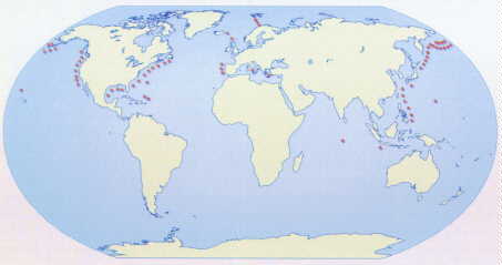
SOUND SURVEILLANCE SYSTEM, or SOSUS, consists of arrays of hydrophones
deployed on the ocean floor. During the early 1980s, some 66 arrays were
operating
at the locations shown here; in the wake of the cold war, the number has
been reduced.
Development work began on SOSUS in 1950 and led to the installation four
years later of the first array of hydrophones on the continental shelf off
the eastern coast of the U.S. The arrays have been periodically updated,
and the technology is now in its fifth or sixth generation of development.
The data collected about each submarine include its sonar echo and the noises
made by its engine, cooling system and the movement of its propellers. The
sounds are translated into a single recognition signal that enables experts
to determine not only the type -- an Alfa-class attack submarine, say, or
a Typhoon-class ballistic-missile submarine -- but also the individual submarine.
Behind the Black Door
Although this global collection of sensors in sea, air and space ably performs
the intelligence and military roles it was meant for, it remained to be seen
whether its data, past and present, could benefit science. The largely
bureaucratic process of answering this question began in May 1990, when then
Senator Al Gore of Tennessee wrote to an official at the CIA. Gore wanted
to know whether the agency possessed databases on the oceans, clouds, tropical
winds and rainfall that would be relevant to various environmental and scientific
issues. It turned out that the agency did have substantial data on many of
the topics listed in the letter. Not long after, CIA officials arranged a
meeting with a few scientists from outside the intelligence community, including
Jeffrey Dozier, dean of environmental sciences at the University of California
at Santa Barbara, and Gordon J. MacDonald, a geophysicist at the University
of California at San Diego.
Prompted in part by another letter from Gore, Robert Gates, then director
of the CIA, granted security clearances in the spring of 1992 to a group
of scientists. The clearances enabled the scientists to study intelligence
data with an eye toward determining its scientific relevance. Eleven panels
based on environmental disciplines were established; to staff the panels,
about 70 scientists were recruited from academia, the private sector and
government agencies such as the Environmental Protection Agency and the National
Oceanic and Atmospheric Administration. At the first official meeting, in
October 1992, the scientists considered environmental data needs and possible
sources.
The scientists also met with some of their noncleared colleagues to compile
a list of critical issues and the information that would be needed to address
them. For example, one of the study groups, on greenhouse gases, identified
ozone as a major concern. To better correlate the abundance of the molecule
with climatic observations, the scientists agreed that they would need to
know the vertical distribution of ozone as a function of season and latitude,
with sufficient accuracy to detect a 5 percent change in 10 years.
Once the scientists had identified their information needs, the intelligence
community -- particularly the CIA and the NRO -- and also the Defense and
Energy departments began to prepare briefings on more than 100 classified
systems and data sets. Then, in late November 1992 and early 1993, the scientists
were ushered into the "black" world of U.S. intelligence technology and its
products. The briefings on past and present collection systems ranged from
space to undersea systems and included a multitude of details, such as their
code names -- a highly classified item of data for intelligence satellites
-- where they were located and the type of data they collected. Besides helping
the scientists determine what archived data might be of value for environmental
research, the briefings were designed to let them consider how currently
operating satellites, sonar arrays and other systems could be employed to
collect environmental data.
In December 1993 the scientists concluded in their first report that there
were in fact wide-ranging environmental-scientific uses for the vast archive
of imagery data and for current photoreconnaissance satellites. One obvious
use of the archived images, they noted, would be the filling in of gaps in
data about changes in patterns of urbanization as well as in boundaries of
vegetated regions and deserts -- changes that are understood to be sensitive
indicators of climate change. The first civilian system, the
Earth Resources
Technology Satellite, was not launched until 1972, and the classified
imagery archives would permit an extension of the data timeline back to the
early 1960s.
The scientists also realized that images from the spy satellites would permit
"calibration" of the lower-resolution civilian systems. By comparing low-
and high-resolution images of the same target, the scientists could extract
additional information from the low-resolution photographs. This calibration
would be especially helpful for vegetation data, allowing, for example, the
determination of species and the degree of foliage coverage.
High-resolution images could also provide an additional level of detail that
would be useful in studying the growth or shrinkage of forest, desert or
wetlands. Moreover, the images could facilitate more detailed studies of
changes in arable land, the integrity of ecosystems and animal habitats,
forest damage from pollution or other human activity, water use and coastline
erosion--all subjects with considerable consequences for human health.
The report also noted that the DSP satellites could be used to detect and
monitor large fires in remote regions; such fires generate the greenhouses
gases carbon monoxide and carbon dioxide. And it suggested that the SOSUS
arrays could be used to detect global warming: sound travels faster through
warm water than through cold water, so measurements of changes in sound speed
over thousands of kilometers of ocean reveal even minute changes in temperature.
SOSUS could also be used to monitor the movements of whales, yielding new
information on their populations. All these suggestions have since led to
active efforts under Defense Department or other auspices.
Approximately 15 experiments were also proposed to try to ascertain whether
intelligence systems could be used to determine the thickness of sea ice,
the extent of deforestation, tropospheric water content and the existence
of radioactive, toxic waste below ground.
Medea Becomes Permanent
Encouraged by the success of the partnership, the intelligence community
moved in 1994 to make it permanent. The name Medea, chosen by CIA official
Linda Zall, came from the character in Greek mythology who helped Jason and
the Argonauts steal the Golden Fleece and who later became Jason's wife.
(Not coincidentally, Zall is the CIA's representative to a group of scientific
advisers to the military that is known as Jason.) There are still approximately
70 scientists who have security clearances as well as access to a program
office in McLean, Va., near CIA headquarters.
So far Medea scientists have produced well over a dozen reports on how archived
data and present collection systems can advance environmental science. The
reports cover such subjects as improving predictions of volcanic eruptions,
better methods of identifying and delineating wetlands, improving estimates
of surf conditions and ocean circulation, and calculating glacier net balance.
All the reports except one are classified.
The single unclassified report,
Scientific
Utility of Naval Environmental Data, was published in June 1995 and
resulted from a navy request to Medea to examine the databases, products
and capabilities of the Naval Meteorology and Oceanography Command. One focus
of the effort described in the elegant, 52-page report was the examination
of the scientific utility of the oceanography command's databases on sea
ice, geology and geophysics as well as ocean volume and boundary properties.
It also includes a number of recommendations on enhancing ocean science
capabilities. For example, it proposes the establishment of an exploitation
center to allow cleared scientists access to most of the command's databases
and suggests that the navy step up its efforts to build regional ocean models,
which simulate sea conditions on computers.
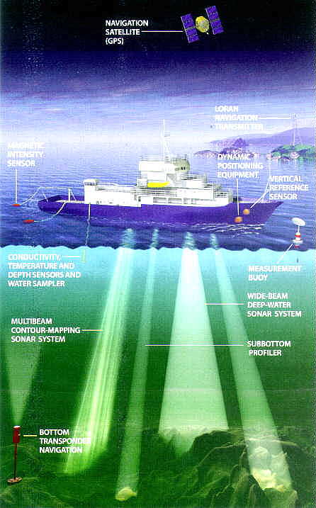
SURVEY SHIP, designated TAGS-60, is the latest in a series dating
back at least four
decades. The U.S. Navy ship, along with other military resources such as
Global Positioning
System (GPS) satellites and long-range ("Loran") radio navigation, is equipped
with a
variety of sensors to measure militarily useful ocean parameters. Sonar systems
map the
seafloor and even probe the area just below the floor.
Medea scientists have also been asked to explore how modifications to current
and planned satellite systems can improve their utility for collecting
environmental data. The result has been approximately a dozen or so "fairly
esoteric" dual-use reports to the NRO, in the words of one of its officials.
The studies contain specific engineering recommendations and are, according
to the same official, "taken seriously" and "will have an impact" on future
intelligence satellites.
Medea has also been instrumental in the design of the Global Fiducials Program,
under which approximately 500 sites of interest to environmental scientists
will become repeated targets of present and future imagery satellites. Among
the prospective targets are clouds off the California coast between Los Angeles
and San Diego; a lowland tropical rain forest at La Selva, Costa Rica; the
Luquillo experimental forest in Puerto Rico; permafrost in Fish Creek, Alaska;
glaciers in Griegsletchner, Switzerland; and the high slopes of Mount Kilimanjaro
in Tanzania.
Herman H. Shugart, a Medea member and environmental scientist at the University
of Virginia, hopes that decades from now the images of Mount Kilimanjaro
will provide evidence of any increase of carbon dioxide in the atmosphere.
One of the first natural indicators of such a buildup would be a thickening
of vegetation in the highest vegetation zones, such as those on Kilimanjaro,
found in high tropical forests. Such an increase in verdancy would be easily
visible in reconnaissance images.
The images will be stored in a classified library at the U.S. Geological
Survey. For the next couple of decades, the data will be available only to
those with the proper clearances. But declassification is expected to make
the vast database available eventually to academic scientists and graduate
students.
Even so, the delay has drawn criticism. Steven Aftergood, director of the
Project on Government Secrecy of the Federation
of American Scientists, declares it "admirable that the intelligence
community will be expanding the collection of environmental data." He hastens
to add, however, that he finds it "troubling that they will maintain [the
data] as classified for decades.
Science and Secrecy
Although most of the work of the Medea scientists has been devoted to the
many reports about intelligence data and systems and their scientific utility,
three scientific papers have been written so far based on classified data.
The papers offer an intriguing initial look at the evolving, still somewhat
uneasy balancing act between the concerns of security and those of science.
The twin pillars of science are replicability -- the ability of one scientist
to reproduce another's findings using the same data -- and verifiability
-- the ability to demonstrate the validity of the findings through
experimentation or observation. Peer reviewers also often want to know about
how, and how well, the data were collected. Here the relevant questions are:
What instruments were used? What capabilities did they possess? How often
were measurements taken and under what conditions?
The use of classified data topples the first pillar, because noncleared
scientists (that is, virtually all academic scientists) cannot gain access
to the information. In addition, peer reviewers will be left at least partially
in the dark when they inquire about the collection mechanisms and procedures.
Dozier notes that in some cases the results of such research can be verified,
even if they cannot be replicated, which would increase confidence in the
classified methods and data used to produce the results. For example, the
accuracy of a topographic map of the seafloor can be checked, even if the
means by which it was originally produced are not known. At the same time,
he acknowledges, such an approach "doesn't work for transient phenomena"
ocean and atmospheric features could well be gone by the time other scientists
seek to verify the results.
Many of these issues are on display in connection with the first two scientific
articles to result from Medea. The one by Medea scientist William H. Schlesinger
of Duke University and Nicholas Gramenopoulos of Mitre Corporation was published
in 1996 in Global Change Biology. The article addressed the question
of whether the desert in relatively pristine areas of the Sudan was on a
southward march. Availing themselves of satellite and aircraft reconnaissance
photographs of the western Sudan taken between 1943 and 1994, the authors
analyzed the abundance of trees at about a dozen sites arrayed in a north-south
direction. The photographs greatly extended the record of vegetation change
in the African Sahel as produced by NOAA's satellite-borne Advanced Very
High Resolution Radiometer since 1980. The authors noted that the expansion
of desert would imply that regional or global climate change was increasing
the probability of famine; what they found, however, was no evidence of
significant change.
The fact that many of the images the authors relied on in formulating their
conclusions are in classified archives ensured that Schlesinger's article
did not appear in the journal Science, to which it had originally
been submitted. Schlesinger recalls that the reviewers for Science
asked questions about availability, resolution and frequency of coverage
that he simply could not answer without divulging classified information.
Although Science does not have a blanket policy prohibiting publication
of such articles, its managing editor, Monica M. Bradford, comments that
"if reviewers can't judge what is presented, we're not going to publish."
Information about the sensors is almost entirely missing. The authors state
that "we used the archive of remotely sensed photography from aircraft and
satellites operated by the Intelligence Community and Department of Defense
to provide a record of the abundance of woody vegetation in Darfur Province,
western Sudan."
The editors of Global Change Biology felt it necessary to add to the
article a caveat, which reads: "Many of the data for this paper are in classified
intelligence archives. As a consequence, the options for evaluating the paper
and for ensuring that other scientists can reproduce the analysis are
constrained. Publication of this paper in Global Change Biology is intended
to illustrate the potential use of, and stimulate discussion on the role
of, classified data in the open scientific literature. Limitations on access
to the data make it impossible for the journal's usual review process to
assess all aspects of data quality, selection or interpretation."
Another Medea-inspired article addresses a subject of growing interest among
astronomers and the general public: the possibility of a sizable meteoroid
crashing into the earth. The article was co-authored by Medea member Thomas
B. McCord of the Hawaii Institute of Geophysics and Planetology.
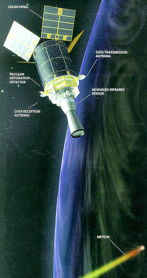
MILITARY SATELLITE known as DSP (for Defense Support Program) has
infrared
sensors capable of detecting the entry of sizable meteors into the earth's
atmosphere.
On February 1, 1994, a DSP recorded the arrival of a meteor that exploded
on entry,
releasing as much as 630 kilotons of energy. The satellites orbit
geosynchronously at
35,900 kilometers. [See also
DSP 16 being launched
from the Space Shuttle]
Interest in the meteoroid-impact issue had previously led the air force to
declassify data from the first 17 years, starting in 1970, of the DSP program.
The DSP satellites were designed to detect the infrared energy released by
explosions ranging in intensity from the destruction of an airplane to a
nuclear detonation. When a reasonably sizable meteoroid enters the earth's
atmosphere, it, too, explodes, emitting a unique infrared signature that
is detectable by the DSPs.
McCord's security clearance enabled him to pore over more recent DSP records
and possibly other data as well concerning a meteoroid that slammed into
the earth's atmosphere on February 1, 1994, over the central Pacific Ocean
not far from the island of Kosrae. McCord estimated that the mass of the
meteoroid was between 500,000 and nine million kilograms. Unconfirmed reports
have held that the explosion of this meteoroid was so great that President
Bill Clinton was awakened in the middle of the night by jittery officials
fearing that a nuclear weapon had detonated in the atmosphere.
McCord's analysis of the event was published in the February 25,1995, issue
of the Journal of Geophysical Research. The records from the DSP and
possibly other sensors enabled McCord to estimate the meteoroid's orbit,
mass, fragmentation and energy release -- which was calculated to be between
34 and 630 kilotons. The paper provided a detailed account of where the meteoroid
was first detected (at an altitude of 54 kilometers), its tracking, its angle
of entry, its breakup in the atmosphere and how the authors calculated its
orbit and energy release.
They did acknowledge that "we must be vague concerning sensor characteristics
that we are not yet at liberty to reveal" and made no explicit reference
to the DSP. The extent of the disclosure about the sources of their data
was the revelation that the sensors included "infrared and visible wavelength
sensors aboard platforms operated by the U.S. Department of Defense."
Emergency Intelligence
It is not part of their official mandate, but Medea members have also been
assisting the intelligence community in its work in monitoring environmental
degradation and emergency situations. The environmental tasks, especially,
were assigned greater priority in 1993 when Presidential Review Directive-12
announced that President Clinton had decided that "environmental issues are
significant factors in U.S. national security policy."
In their environmental activities, some of which are focused on Russia and
eastern Europe, Medea scientists have assisted intelligence community analysts
in assessing the effect of a series of oil spills in the Komi region of Russia
and of Russia's disposal of chemical weapons in the Arctic. According to
an NRO official, the imagery analysts at the Defense Department's National
Imagery and Mapping Agency "learned some tricks" from the scientists with
respect to processing and also "fusing" data -- combining the output of different
sensors (such as visible-light and radar imagers) and using it to produce
a single product (such as an image) that contains more information than any
of its components.
Several Medea scientists have also been participants in the Environmental
Working Group of the commission headed by Vice President Gore and Russian
Premier Viktor Chernomyrdin. Among the group's efforts has been the exchange
of satellite imagery and imagery-derived data to assist in the environmental
cleanup of areas surrounding military facilities.
Recent emergencies that have attracted the attention of the intelligence
community and Medea include the flooding in the winter of 1996-97 in northern
California and subsequent hurricane damage in the southeastern U.S. Medea
researchers also helped to monitor changes in the volcano on Montserrat shortly
before it erupted in 1995. The monitoring led to an official warning to the
island's government, which was able to evacuate 4,000 people from the danger
zone.
Tracking the wildfires that raged in Alaska in June 1996 presented a problem
for the U.S. Forest Service, which did not have enough airplanes to chart
the extent of the fire. The task was an easy one, however, for reconnaissance
and the DSP satellites.
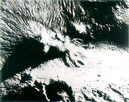
VOLCANO, one of the world's highest, is on the Kamchatka Peninsula
in
Russia's far east. Comparison of reconnaissance images, such as this one
from
1962, provides insights into the history of volcanic activity on the peninsula,
an extremely active area both seismically and volcanically.
Medea's Future
Although Medea has had undeniable successes, a few issues will need consideration
in the near future, especially if the program expands. Among them is a fear
that extensive use of classified data by civilian agencies could inhibit
free and open discussion of some of their policies. The worry is that officials
will be restricted in their public remarks and, moreover, that outside experts
will lack full access to the data on which policies are made and justified.
Another concern is that use of intelligence systems for environmental research
will inhibit the use of a planned generation of relatively high resolution
commercial satellites for environmental research -- the results of which
could be made available immediately to a much wider audience.
Already one misgiving -- that nonintelligence applications would take up
too much of the time of key intelligence resources -- has been proved unfounded.
According to Bo Tumasz, the CIA's environmental intelligence program manager,
the environmental collection effort occupies less than 1 percent of the time
of reconnaissance satellites.
Against these worries must be weighed the demonstrated and potential benefits
of Medea. In addition to promising the availability of a well-designed
environmental database for scientists in the 21st century, Medea serves as
a well-informed advocacy group in favor of further declassification. For
example, Medea scientists have already proposed releasing environmentally
relevant satellite imagery up through the present, with the true resolution
of present satellites obscured by the release of coarser images. Intelligence
officials ultimately rejected the proposal, but without the Medea program,
such a possibility probably would not have even been considered.
Clearly, Medea itself is as much an experiment as is the work of its
participants. And as with any experiment, there will be theories, unexpected
findings and, one hopes, progress as this unique collaboration between scientists
and spies matures.
The Author
JEFFREY T. RICHELSON is currently a senior fellow with the
National Security
Archive in Washington, D.C. He is the author of seven books on intelligence,
including America's Secret Eyes in Space: The U.S. Keyhole Spy Satellite
Program and A Century of Spies: Intelligence in the Twentieth
Century. In 1975 he was awarded a PhD. in political science from the
University of Rochester. The views expressed here are not necessarily those
of his employer.
Further Reading
CORONA: SUCCESS FOR SPACE RECONNAISSANCE: A LOOK INTO THE COLD WAR. Robert
A. MacDonald in Photogrammetric Engineering and Remote Sensing, Vol.
61, No. 6, pages 689-720; June 1995. [See also:
http://www.nro.odci.gov/corona.html]
A MOMENT ON THE EARTH: THE COMING AGE OF ENVIRONMENTAL OPTIMISM. Gregg
Easterbrook. Viking, 1995.
SCIENTIFIC UTILITY OF NAVAL ENVIRONMENTAL DATA. Medea Program Office McLean,
Va., 1995 (telephone: 703-883-5265).
USING INTELLIGENCE DATA FOR ENVIRONMENTAL NEEDS: BALANCING NATIONAL INTERESTS.
Scott Pace et al. Rand, Santa Monica, Calif., 1997.
[End]
Hypertext by JYA/Urban Deadline